Since 2017, the CGA has enjoyed an excellent partnership with Dr. Katsuhiko Oda of the Spatial Sciences Institute at University of Southern California. Dr. Oda has been successful is securing funds to support research on the effectiveness of professional development focused on geospatial technology, and this creates opportunities to provide high quality professional development to California’s teachers. CGA’s experience providing PD matches perfectly with Dr. Oda’s research and teaching interests. Work carried out during the 2017-18 school year was presented at the GIS-Pro / CalGIS Conference in Fall 2018. This year, a grant from Esri, the world’s leading provider of GIS software, provided support for further work. Continue reading Teaching with Geospatial Technology
3 Fun Ways to Accelerate Geographic Learning for Your Students
The 2018-19 school year has barely started, yet here come the holidays, ready or not! We hope it has a wonderful Fall of geographic learning and exploring for educators, students, and all residents of California. The CGA continues to be the one organization in the state focused on promoting and supporting geography education in K-12 schools as well as in after school and informal learning settings. This update is a quick orientation to opportunities for schools, students, and educator, and we have partnership news to share as well, so please read on.
Join 10,000 Schools and Participate in this Year’s National Geographic GeoBee!
Organizing a GeoBee at your school can be a fun way to promote geographic awareness and a global mindset. Registration for the 2018-2019 school year is now open. Any paid school employee can register their school for the National Geographic GeoBee. The registration fee is $120. Schools needing financial support can complete a Registration Discount Request form. Read the full list of rules here. Continue reading 3 Fun Ways to Accelerate Geographic Learning for Your Students
Geography and the H-SS Framework
CGA is Participating in the Statewide Community of Practice for the Content, Literacy, Inquiry, and Citizenship (CLIC) Project (AKA H-SS Framework Rollout 2.0)
As part of the first day of the proceeding, CGA Director Tom Herman gave a short presentation on content knowledge in geography. To access the slides used in the presentation, click here. Please consider including geography and the CGA in Regional Communities of Practice and district Professional Development plans.
Sweetwater Union High School District Uses World Geography and Global Issues Course as Launching Pad for Civic Action
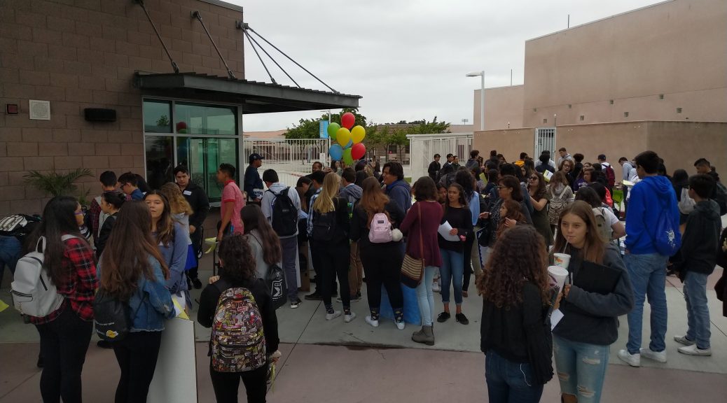
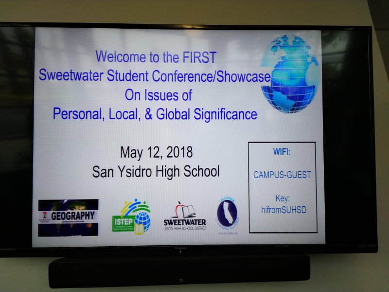
The CGA has an ongoing partnership with SUHSD and ISTEP / California Global Education Project to support the district’s World Geography and Global Issues Course and use it to develop new and innovative ideas for inquiry-based instruction and student engagement. The course has incorporated a year-ending action research project, and this year the work of students was showcased in the first ever Student Conference/Showcase on Issues of Personal, Local, & Global Significance. The event was the brainchild of teachers Kelly Leon and Gina Vattuone, and both the CGA and CGEP stepped forward to help secure speakers, provide refreshments, and offer critical feedback to the students presenting their research.
Perceptions & Knowledge of Geography on an American College Campus
As part of an upper-division Qualitative Research Methods in Geography class at San Diego State University in Fall 2017, students under the guidance of Dr. Kate Swanson researched, surveyed and interviewed geography majors and future social studies teachers to measure students’ basic geographic knowledge and determine how they perceive geography’s value as a discipline. In releasing the report Perceptions & Knowledge of Geography on an American College Campus, Dr. Swanson wrote the following:
“To our surprise, we discovered that interest in and enthusiasm for geography education is high. As stated by one of our interviewees, ‘I just wish that as a teacher, I would have more understanding of geography.’ In our report, we suggest that there may be a window of opportunity to expand geography education, particularly in K-12 schools.
In the report, we present our findings, along with a series of recommendations for incorporating more geography into our educational curriculum. Our main recommendations are as follows:
– Actively promote geography’s interdisciplinary approach as a strength;
– Promote more study abroad opportunities in geography;
– Host more geography awareness events;
– Create a university level ‘Geography for Educators’ course;
– Support moves to bring geography and geospatial technologies into K-12 schools;
– Rebrand geography by highlighting its relevance to today’s global problems;
– Promote tools and technologies that enhance geographic education and spatial learning;
Given our findings, we believe that teacher education in geography is especially important. American teachers recognize the value of our discipline, yet they have little experience with geography education.
Please feel free to share this report widely. I want to reiterate that this report was researched, written and designed by seniors at SDSU!”
A Study of Young People’s Geographical Knowledge, Global Awareness, and Attitudes Toward Geography Education
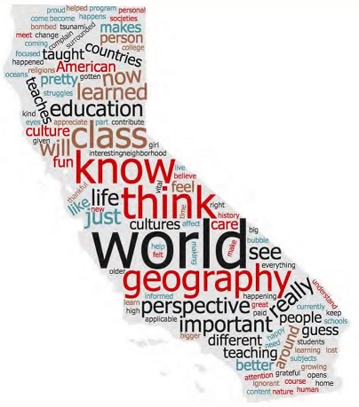
Students in Dr. Kate Swanson’s Qualitative Methods in Geography upper division course took on a special assignment last year. They constructed a research project that examined young people’s geographical knowledge, global awareness and perspectives on geography education. The young people under study included both undergraduates at San Diego State University and high school students in Sweetwater Union High School District who had taken the district’s World Geography and Global Issues course. While one finding is that there is still a lot of room for improvement in young people’s geographical knowledge, the report also indicates that young people have increasingly global concerns and see geography courses as extremely useful in helping them to make sense of the issues confronting and connecting people around the world. You can review the report here.
There are some interesting excerpts from interviews conducted with 24 Sweetwater students. For example,
Question: Do you think American students need a geography education?
Answer: “Yeah, because I don’t think most kids know what is going on in the world. Like, I don’t think a person who doesn’t have a geography class knows what’s going on in Syria…”
Understanding Natural Hazard Risks: Hurricane Harvey, the California Megaflood of 1861-62, and the Future
The Houston Metro area and large areas of southeast Texas have been devastated by record flooding caused by Hurricane Harvey. There was tragic loss of life, and astronomically expensive damage to property and infrastructure. There will be a lot of discussion about how more frequent severe storms are a part of global climate change, and we can also focus on the science of weather forecasting, which continues to advance with new computational models and satellite data being utilized. But a very important point for us to reflect upon is how we could have done a better job of planning how we built our cities and infrastructure to protect against this loss of life and costly damage to property.

The fact is, catastrophic flooding in the Houston area was a highly predictable event. The National Flood Hazard Map maintained by FEMA can be viewed online here. Once the map is open, you can Continue reading Understanding Natural Hazard Risks: Hurricane Harvey, the California Megaflood of 1861-62, and the Future
BREAKING NEWS – Winners of My California GIS Mapping Competition
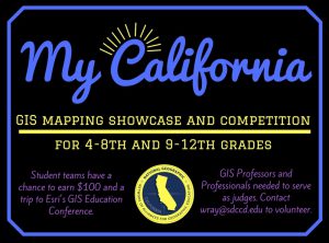
The CGA’s first ever statewide GIS mapping competition for 4th through 12th grade students has concluded. 5 students projects have been selected as state finalists in each of two divisions. The authors of each project will be awarded a prize of $100, and the projects will be advanced to the national competition. 5 other projects have been selected for Honorable Mention.
The CGA wants to thank:
- the NorCal Chapter of URISA and the California Geographic Information Association for their generous support of this competition;
- the 29 schools that registered for the competition, including all the teachers and students who invested their time in creating projects about their state;
- all of the judges who lent their time and expertise to scoring the entries and selecting the very best;
- and Dr. Waverly Ray who took the lead in coordinating the competition and brought enthusiasm and skill to the task!
Without further ado, we present the winners. Continue reading BREAKING NEWS – Winners of My California GIS Mapping Competition
Meet the Judges for the My California GIS Mapping Exhibition and Competition
Janet Brewster
GIS Specialist, California Department of Fish and Wildlife
- My career has spanned multiple disciplines, and GIS has moved right along with me. From environmental planning to facilities to land and wildlife conservation, I have been able to use GIS to conduct analyses, create and manage data, and make connections that weren’t otherwise possible. But perhaps best of all, I can share all of this information on a map, rather than in a dry list of names and numbers. Who doesn’t love a good map?!
Continue reading Meet the Judges for the My California GIS Mapping Exhibition and Competition
Get Your Students Involved in the My California GIS Mapping Exhibition and Competition!
UPDATE:
With registration for the competition now closed, the CGA is happy to report that 29 schools have registered for the competition. That could mean as many as 145 student entries in the state final!
An illustrious panel of eleven judges has stepped forward to evaluate and rank the student entries, so we are all set for an exciting competition. Thank you to all of our volunteer judges!
Click here to see a map of schools registered for the competition.
_______________________________________________________________________
The California Geographic Alliance is hosting an exciting statewide mapping showcase and competition that encourages middle (4th-8th grade) and high school (9th-12th grade) students to harness the power of Geographic Information Systems and get connected with their state by producing an online map that focuses on stories, issues, or ideas that are important to them.
Registrations due March 15, 2017!
Go to the contest page for full details.
Thanks to the Northern California URISA Chapter and the California Geographic Information Association for their generous support of this effort!