Report from BioBlitz 2014 at Golden Gate National Parks

BioBlitz2014

By Roni Jones

#BioBlitz2014 at Golden Gate National Parks in San Francisco was an exhilarating and inspiring event for students, educators, scientists, and citizens. National Geographic Education staff started the week by spending Tuesday, March 25 at John Muir Middle School in Corcoran, California, just south of Fresno, to conduct a Schoolyard BioBlitz with 240 7th grade students. Over three hours, students visited three different sites in town and on campus to observe birds, insects, animals, and plants. JMMS is a Verizon Innovative Learning School and an Apple Distinguished School, and has implemented a 1:1 iPad ratio for students and teachers. With this technology, students were able to utilize the iNaturalist app to identify and document different species throughout the day. Students were most excited to observe owl pellets containing animal bones, feathers, and other indigestible matter. Information and video collected during the Schoolyard BioBlitz will ultimately be available for educators so they, too, can organize and conduct their own local species inventories.

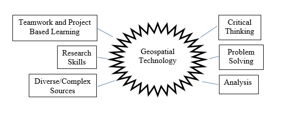
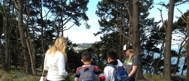
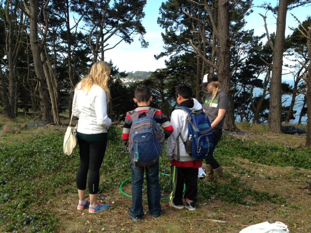
At noon on Friday, March 25, BioBlitz 2014 was officially launched, although students and scientists had started collected data early that morning. The staff at Golden Gate National Parks, as well as Golden Gate National Parks Conservancy and the Presidio Trust, coordinated hundreds of naturalists, docents, birdwatchers, and other volunteers to work with more than 3,000 students throughout the day. Students were scattered throughout the Bay Area from San Mateo to the Marin Headlands to conduct inventories about what types of bird, reptile, mammal, plant and insect species were observed. It was amazing to see so many students actively involved in field science and engaged so fully with their local environment. The weather was spectacular and the students were also able to enjoy a large festival of hands-on activities at Crissy Field, in the shadow of the Golden Gate Bridge.

The public and scientific inventories continued into Friday night and Saturday morning, even though the weather turned stormy and wet. Volunteers returned to the field throughout the 24-hour period to inventory tide pools and identify nocturnal creatures. The first-ever inventory of the canopy of the redwood forest in Muir Woods was conducted. In total, 300 scientists, 3,000 students, and over 5,000 volunteers took part in this unique and exciting event.

Next year, #BioBlitz2015 will take place at Hawaii Volcanoes National Park, so make your vacation plans now to participate!

Bringing GIS into the Classroom: Ideas for Teachers of All Disciplines

By Trevore Humphrey
Note: This article is based on a presentation given at the 2014 California Council for the Social Studies Conference.

Geographic Information Systems (GIS) is designed to capture, store, manipulate, analyze, manage, and present all types of geographical data. Google Earth as well as other modern online GIS tools has greatly added to the list of free and accessible geospatial technology that teachers can use as a powerful tool in their classrooms, and this article will provide some ideas for science, Math, and English classrooms.

While great traditional map sources like National Geographic “One-Pager Maps” offer great hands on opportunities for students to work in geography, geospatial technology offers students a far more dynamic medium to work in. There are two main paths to using GIS in the classroom; Instructional and Project Based Learning (PBL).

PBL can be easily implemented by combining a research project with GIS to have students create content on their maps and present their research to their classmates using this medium

  • EX: Student(s) creates basic map and tour that shows the paths of migration and settlement in early America.
  • EX: Student(s) creates map that compares and contrasts basic U.S. census data from two different decades. Map highlights and describes significant changes over time.

Links to sites where students can create maps:
http://mapmaker.education.nationalgeographic.com/
https://mapsengine.google.com/map/

Instructional uses fall into three major categories that are as follows.

  • Direct Instruction: Part of lecture or activity. GIS programs can be quickly and easily used as an instructional reference map with greater detail and accuracy than any paper or static map.

    EX: Showing student(s) historically significant physical markers like the Panama Canal or the Great Wall of China.

  • Independent Study: Excellent digital resource.
  • EX: Have student(s) complete an “Earth Quest” in which they explore the map you have created and answer questions and prompts as they go.

  • Review: Good format for unit review.

    EX: Create a comprehensive review for a unit exam by narrating an audio tour (Google Earth) which covers the content and concepts students need to know for the exam. Post file online for students to access at their convenience. Include content check questions along the way.

Geography has been often restricted to the Social Studies classroom and is often only covered there but with the opportunities that GIS offers we can bring geography into multiple disciplines. The following are brief descriptions with links that support geospatial technology use outside the social-studies.

Science: The core subject of science and in particular, earth science and environmental science are areas that can be greatly aided by using geospatial technology. There already is a plethora of models and data out there for teachers to use. For some great k-12 earth science activities and lesson plans for Google Earth visit the Earth and Space Science QUEST by Penn State.

Math: To make math more tangible, real world based GIS offers the ability to measure distances, area, latitude and longitude: intersecting lines, angles, etc. Instead of having students answer the classic, “If train A is going 50mph and is 340 miles…” have students actually find a railroad and calculate a real distance (S.F.-L.A.) that they measure. For more examples and full lesson plans visit http://www.realworldmath.org/

English: We ask students to look up vocabulary terms that are new to them when they are reading. They should also be looking up locations and places they read about but are not familiar with. This will strengthen understanding through generating geographic context, mental maps, and spatial relationships. A great resource for teachers is Google Lit Trips which is a site full of Google Earth models for a variety of fiction and non-fiction books k-12 students read. And creating a Google Lit Trip could be a great project to accompany reading a novel.
While geography still remains a largely social studies discipline GIS offers teachers a technology that can support interdisciplinary work as well as help meet the goals of the new Common Core standards. The following are some of the few benefits of having students work with GIS no matter what class they are in.

geospatial technology benefits graphic

In conclusion, there are a wide variety of GIS programs; some that are simple and quick to use such as National Geographic MapMaker interactive or Google Maps; some that are a bit more advanced and offer greater complexity such as Google Earth or ArcGIS Online. No matter what GIS program you might use for your class the result will be a new, dynamic, and engaging approach to incorporate geography and technology into your classroom.

– Trevore Humphrey

.

USS Midway Museum Summer Teacher Institute – Opportunities for CGA Members!

CGA has reserved spaces for a few members (high school teachers) to participate in the USS Midway Museum’s 2014 Midway Institute for Teachers. The institute offers two weeks of professional development on teaching about the Cold War era, its origins and effects, the Korean War, the Vietnam War and era, and presidential decision-making. These CGA members will join a group of thirty teacher/scholars selected to participate in a specialized institute in downtown San Diego from June 16-27, 2014. The seminar will be held aboard the USS Midway, an artifact of that era and the only aircraft carrier to serve the entire duration of the Cold War.

For more information and to apply to this program, go to: http://www.midway.org/midway-teacher-institute

Please indicate on your application that you are a CGA Member. Travel costs and stipend are provided.

Atlas Professional Development Workshop in San Diego on May 10, 2014

This workshop is at capacity, but interested teachers are encouraged to register to be put on a wait list. We will notify teachers if spots open up and give them priority for future workshops.

The first of four upcoming atlas workshops has been announced, and it will be held at the San Diego County Office of Education from 9 a.m. to 3 p.m. on May 10. These workshops are free for any fourth grade teacher, and space is limited, so reserve your spot now. For more information about this workshop and to register, visit the Professional Development page.