The CGA is happy to present a set of resources designed to help educators and students engage in inquiries into the effect of the Cold War on perceptions and representations of the world as well as the use of maps and geographic information as rhetorical weapons in the execution of the Cold War.
This information was assembled to support the Midway Summer Teacher Institute. Dr. Tim Barney was a featured speaker at the institute in 2015 and 2016, and a video of his lecture — in which he presents a detailed analysis of one particular map’s purpose, production, and use in various contexts — is available here: “The Rhetorical Lives of Cold War Maps” (will open in new window).
Please also access our Cold War Map Gallery here (will open in new window).
___________________________________________________________________________
Click here to download the content below as a printable pdf.
___________________________________________________________________________
An Intro to Cold War Maps and Images
Visualizing Global Geopolitics
Presented by
The California Geographic Alliance
and
The San Diego State University Geography Department
This introduction and overview was developed to accompany an assortment of 9 large maps displayed during the Midway Summer Teacher Institute. It presents a collection of small images reflecting the politically and tactically informed perspectives on, and representations of, the world prevalent during the Cold War. The Cold War period called for careful re-mapping of the world in a nuclear age. Maps also created powerful imagery that informed the public about the realities of how the struggle between superpowers and ideologies was organizing space around the globe.
All images were obtained online, and source information is provided.
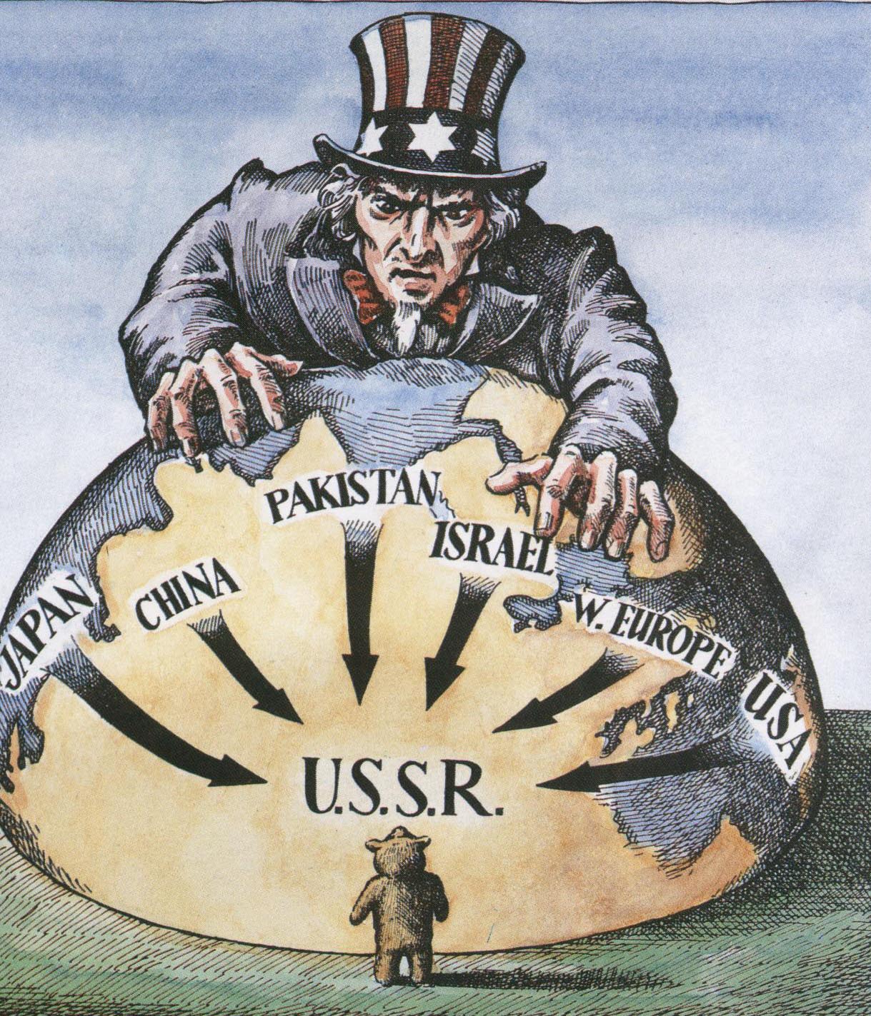

The Geography of Power
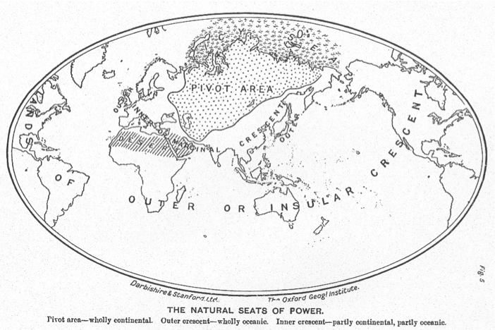
Sir Halford Mackinder, The Natural Seats of Power, 1904
In 1904 Mackinder gave a talk at the Royal Geographical Society entitled ‘The Geographical Pivot of History’ (read), which was illustrated with this world map. Mackinder believed that central Asia, or what he called ‘Eurasia’, represented the pivotal area of the world’s politics, and that whoever controlled this vast, landlocked region and its resources would effectively rule the globe. The map influenced generations of thinkers and politicians, from George Orwell’s dystopian world of 1984 to the US foreign policy promoted by Henry Kissinger and Zbigniew Brzezinski.
https://www.foreignaffairs.com/articles/1954-04-01/pivot-history

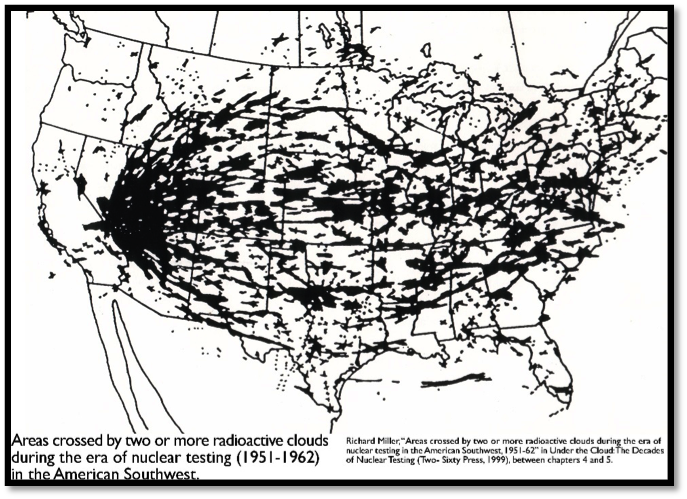
Previously viewed as a chokepoint in naval warfare, the narrow gap between Greenland, Iceland and the UK became the main “highway” used by Soviet bombers and maritime reconnaissance aircraft flying to Cuba, monitoring NATO maritime activities or simply probing local air defenses.
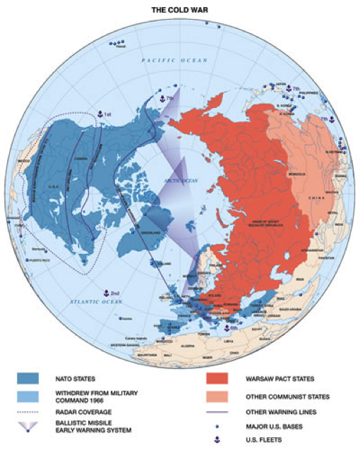
Azimuthal projections became popular because their conservation of true distance was usefulness in showing the range of aircraft and missiles. The polar azimuthal projection seen here also emphasizes the proximity between the US and USSR.
http://www.markfranklinarts.co.uk/index.php?page=13&display=64&parent=2&sub_menu=9
The Iron Curtain in Eastern Europe
This cartoon by the British cartoonist Illingworth was published in June 1947
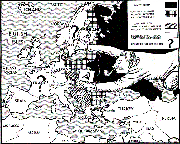
Accessed at: http://www.johndclare.net/cold_war6.htm
1946 map of the “Iron Curtain” reflecting the assertions made in a Winston Churchill speech.
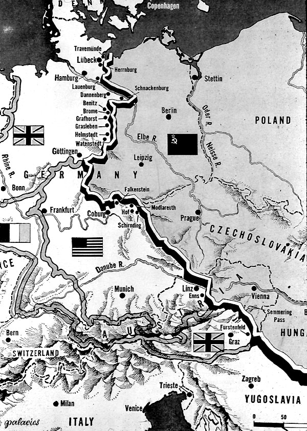
“From Stettin in the Baltic to Trieste in the Adriatic, an iron curtain has descended across the [European] Continent.”
On March 5, 1946, a train with two World War II statesmen left Washington D.C. and steamed across the United States to the gateway to the west, Missouri. In the town of Fulton, population 7,000, at Westminster University, former British Prime Minister Winston Churchill, with President Harry Truman by his side, delivered a prophetic speech to an audience of 40,000 students. Titled “The Sinews of Peace” the oratory soon became known as “The Iron Curtain Speech” (read/listen), referring to the figurative curtain that had fallen, separating democratic western Europe and Communist Eastern Europe.
Image and text from http://alinefromlinda.blogspot.com/2012/03/iron-curtain-speech.html
Containment of the Communist Threat in Asia and Latin America
 This was a piece of election propaganda distributed by the Liberal Party during the Federal election on 26 November 1966. The graphic shows the encroaching “red menace” coming southwards from China through South-east Asia towards Australia.
https://studyingthehumanities.files.wordpress.com/2013/07/containment.jpg
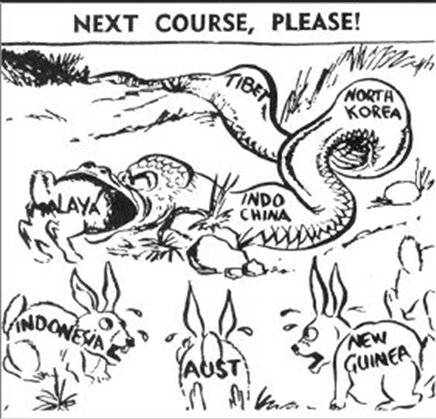
Catholic News Weekly , July 21 1954 https://studyingthehumanities.files.wordpress.com/2013/07/containment.jpg
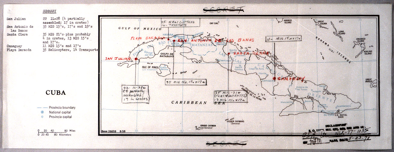
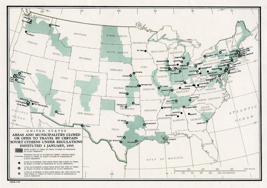
The United States became increasingly vigilant against the potential for communism’s spread into the Western Hemisphere.
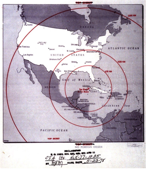
The maps above and below from the JFK Presidential Library are declassified CIA maps updated by hand to provide information on key locations related to the Cuban Missile Crisis
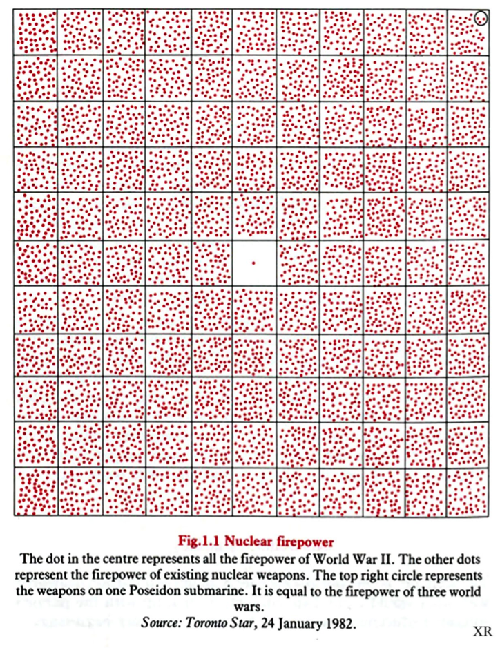
The map below was created in 1990 using data from FEMA and the National Resources Defense Council. The 2,000-warhead attack assumes a first strike by the Russians. The 500-warhead attack would be a retaliatory strike in the event the United States launched first, thus limiting the Russian arsenal.
