
The California Geographic Alliance is proud to announce the winners of the 6th Annual My California GIS Mapping Showcase and Competition.
This exciting statewide opportunity encourages middle (4th-8th grade) and high school (9th-12th grade) students to harness the power of Geographic Information Systems (GIS) and get connected with their state by producing a StoryMap that focuses on stories, issues, or ideas that are important to them. The state competition is part of a national competition sponsored by Esri, creators of ArcGIS Online software and educational resources that are freely available to K-12 schools. $1,000 in prize money is distributed to the students producing the top five projects in each division. The first place project in each division will also be advanced to the national competition.
The mapping contest is coordinated by Dr. Waverly Ray, Associate Professor of Geography at San Diego Mesa College. A panel of academic and industry experts, all of whom serve as volunteers, serve as competition judges (and sometimes mentors, too). This year, we were fortunate to have the involvement of Bryan Ferri, Nancy Ferris, and Robert Kraft. Dr. Ming-Hsiang Tsou, Professor of Geography at San Diego State University, has served as head judge for the competition since its inception. The CGA is grateful for this support and for the advocacy of these individuals to support GIS in K-12 education!
The CGA also sincerely thanks all of the educators across the state who, despite all the challenges of this year, gave their students the great experience of using GIS to create their own maps and projects. Beyond those teachers who register and submit projects for this competition, we know there are many, many more who are creating meaningful learning experiences and helping their students learn about the world around them. Teachers are the best, and we appreciate your help in bringing the power of geographic thinking and geospatial technologies to your students.
And now the real stars of the show…
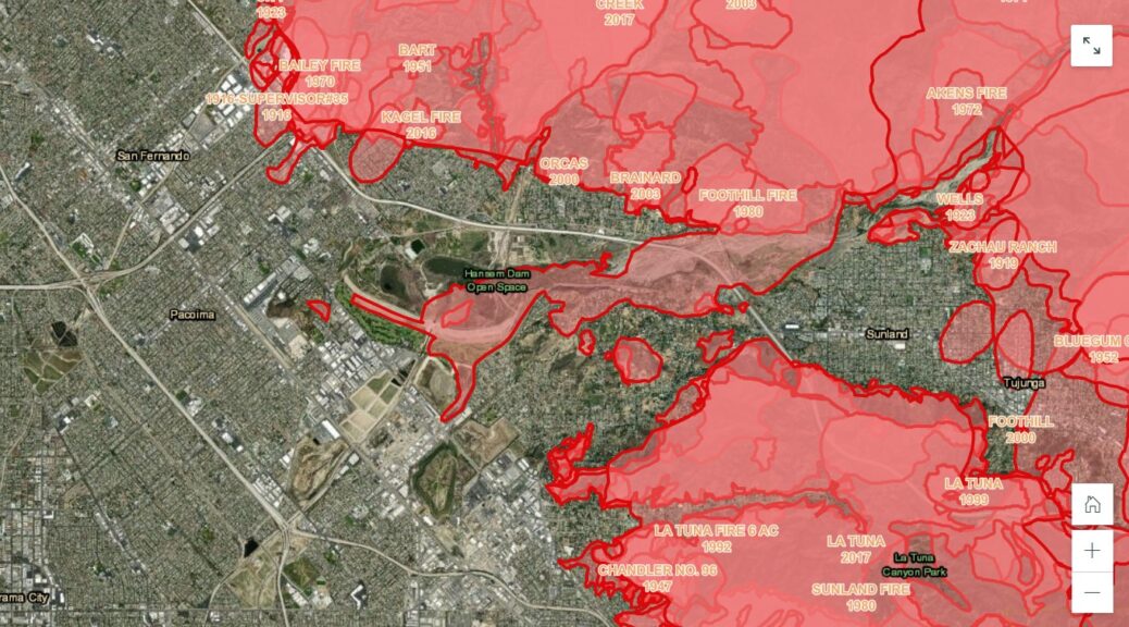
The first place prize in the 9th-12th grade division is awarded to Daniel Bet Sarghez and Matthew Keshishian of Clark Magnet High School in La Crescenta (L.A. County) for a project entitled “CTE Mission: CubeSat.” This StoryMap highlights the work of the school’s GIS and Remote Sensing team. The group entered a national competition and ended up implementing the project they designed to map homeless encampments in high-risk fire zones in Los Angeles. They collected their own data using remote sensing techniques.
The first place prize in the 4th-8th grade division is awarded to Olivia Shekou of Ross School in Ross (Marin County) for a project entitled “Rising Sea Levels.” This StoryMap goes beyond describing the impacts of climate change and rising sea levels to inspire action. The author applies documentary film-making concepts and calls it a “mapumentary.”
Other students recognized in the 9th-12th grade division include:
- Second place: Israel Jurado, Bonita Vista High School, Los Angeles: Median Household Income and School Attendance
- Third place: Kaitlin Bertrand, Bonita Vista High School, Chula Vista: Dance in High School
- Fourth place: Ervin Kamali, Clark Magnet High School, La Crescenta: Cannabis Cultivation in California
- Fifth Place: Tadeh Peroomian, Clark Magnet High School, La Crescenta: Classroom Purifier or a Live Wire?
Other students recognized in the 4th-8th grade division include:
- Second place: Gabriela Bizarro and Diana Sorto, Hollenbeck STEM Magnet, Los Angeles: Air Pollution in Boyle Heights
- Third place: Alegra Huck and Charles Sutro, Ross School, Ross: Shark Attacks in California
- Fourth place: Matthew Arce, Hollenbeck STEM Magnet, Los Angeles: The Liquor Store Story: Difficulties Young Students can Face
- Fifth Place: Abigail Silva and Aimee Rios, Hollenbeck STEM Magnet, Los Angeles: Rent and Income in Los Angeles
Congratulations to all fourteen students who received awards in our two divisions! Congratulations also to the teachers who supported them: Robert Holland and Kelly Leon at Bonita Vista High School; Dominique Evans-Bye at Clark Magnet High School; Rafael Cruz at Hollenbeck Middle School, and; Blake Schmidt at Ross School.
